Article
Diggity Archaeological Site
The Diggity archaeological site is located at the southeastern end of Spednic Lake, near the entrance to Palfrey Lake, in southwestern New Brunswick.
Signing up enhances your TCE experience with the ability to save items to your personal reading list, and access the interactive map.
Create AccountArticle
The Diggity archaeological site is located at the southeastern end of Spednic Lake, near the entrance to Palfrey Lake, in southwestern New Brunswick.
"https://d3d0lqu00lnqvz.cloudfront.net/media/media/5c63f682-2f7c-40a8-b0d4-287fd7865464.jpg" // resources/views/front/categories/view.blade.phphttps://d3d0lqu00lnqvz.cloudfront.net/media/media/5c63f682-2f7c-40a8-b0d4-287fd7865464.jpg

Article
The Droulers-Tsiionhiakwatha archaeological site is located in extreme southwest Québec, in Saint-Anicet in the Haut-Saint-Laurent area.
"https://d3d0lqu00lnqvz.cloudfront.net/media/media/9a4f5824-4fef-4ee0-8b04-92257d768832.jpg" // resources/views/front/categories/view.blade.phphttps://d3d0lqu00lnqvz.cloudfront.net/media/media/9a4f5824-4fef-4ee0-8b04-92257d768832.jpg

Article
Excavations at Ferryland, Newfoundland, 72 km south of St John's, have revealed a remarkable record of European exploitation and settlement during the first two centuries after John Cabot's visit in 1497.
"https://d3d0lqu00lnqvz.cloudfront.net/media/media/bce6fa19-99d1-4c3a-a8ef-b1e1b19b2f3e.jpg" // resources/views/front/categories/view.blade.phphttps://d3d0lqu00lnqvz.cloudfront.net/media/media/bce6fa19-99d1-4c3a-a8ef-b1e1b19b2f3e.jpg

Article
Frontenac reoccupied the site, rebuilding the fort in 1695, and the post became known as Fort Frontenac. Reinforced by troops under François-Charles de Bourlamaque and later the Marquis de MONTCALM, it nevertheless fell to the British under John Bradstreet in August 1758.
"https://d3d0lqu00lnqvz.cloudfront.net/media/media/224b2211-a1a9-4b89-888f-fab9972af144.jpg" // resources/views/front/categories/view.blade.phphttps://d3d0lqu00lnqvz.cloudfront.net/media/media/224b2211-a1a9-4b89-888f-fab9972af144.jpg

Article
Gray Burial Site, north of Swift Current, Sask, lies on a sandy hillside west of an ancient glacial outwash channel.
"https://www.thecanadianencyclopedia.ca/images/tce_placeholder.jpg?v=e9dca980c9bdb3aa11e832e7ea94f5d9" // resources/views/front/categories/view.blade.phphttps://www.thecanadianencyclopedia.ca/images/tce_placeholder.jpg?v=e9dca980c9bdb3aa11e832e7ea94f5d9

Article
Head-Smashed-In Buffalo Jump is an archaeological site located on the southern end of the Porcupine Hills in southwest Alberta.
"https://d3d0lqu00lnqvz.cloudfront.net/media/media/044efca3-4d40-4efa-b5ae-4f9f20403ea4.jpeg" // resources/views/front/categories/view.blade.phphttps://d3d0lqu00lnqvz.cloudfront.net/media/media/044efca3-4d40-4efa-b5ae-4f9f20403ea4.jpeg

Article
The term Hochelaga historically referred to an Indigenous village the French explorer Jacques Cartier (1491-1557) visited on Sunday, 3 October 1535, during his second voyage in what is now Quebec (1535-1536). Hochelaga is an Iroquoian term which is either a variation of the word osekare, meaning “beaver path,” or of the word osheaga, which translates as “big rapids.” Today, Hochelaga refers to islands at the confluence of the St. Lawrence and the Ottawa rivers, as well as various electoral and city districts.
"https://d3d0lqu00lnqvz.cloudfront.net/media/media/dd48df83-e33a-4d14-9707-34c0c6322d48.jpg" // resources/views/front/categories/view.blade.phphttps://d3d0lqu00lnqvz.cloudfront.net/media/media/dd48df83-e33a-4d14-9707-34c0c6322d48.jpg

Article
The Igloolik archaeological sites are located on the islands at the northern end of Foxe Basin, close to the village of Igloolik.
"https://d3d0lqu00lnqvz.cloudfront.net/media/media/737bdeaf-7011-4762-b6ab-67bc228da8ad.jpg" // resources/views/front/categories/view.blade.phphttps://d3d0lqu00lnqvz.cloudfront.net/media/media/737bdeaf-7011-4762-b6ab-67bc228da8ad.jpg

Article
The site of the Intendant's Palace is in the Lower Town of Québec City below the Côte du Palais.
"https://www.thecanadianencyclopedia.ca/images/tce_placeholder.jpg?v=e9dca980c9bdb3aa11e832e7ea94f5d9" // resources/views/front/categories/view.blade.phphttps://www.thecanadianencyclopedia.ca/images/tce_placeholder.jpg?v=e9dca980c9bdb3aa11e832e7ea94f5d9
Article
The Jemseg archaeological site (Borden site designation number BkDm-14) is a major archaeological site located in south-central New Brunswick, on the stream that connects the Grand Lake system to the lower Saint John River.
"https://d3d0lqu00lnqvz.cloudfront.net/media/media/a7ddfad9-aa2e-425b-b65a-3fbd6a372095.jpg" // resources/views/front/categories/view.blade.phphttps://d3d0lqu00lnqvz.cloudfront.net/media/media/a7ddfad9-aa2e-425b-b65a-3fbd6a372095.jpg

Article
Located 21 km north of Winnipeg, Kenosewun Visitor Centre and Museum is a provincially operated facility. The archaeological site interprets the evolution of Aboriginal cultures in the Red River area.
"https://www.thecanadianencyclopedia.ca/images/tce_placeholder.jpg?v=e9dca980c9bdb3aa11e832e7ea94f5d9" // resources/views/front/categories/view.blade.phphttps://www.thecanadianencyclopedia.ca/images/tce_placeholder.jpg?v=e9dca980c9bdb3aa11e832e7ea94f5d9
Article
The Laidlaw archaeological site (Borden site number DlOu-9) is a pit trap used by pre-contact Indigenous peoples to hunt antelope and possibly bison as well.
"https://d3d0lqu00lnqvz.cloudfront.net/media/media/13535b83-9fbb-4558-848c-6989f7457150.jpg" // resources/views/front/categories/view.blade.phphttps://d3d0lqu00lnqvz.cloudfront.net/media/media/13535b83-9fbb-4558-848c-6989f7457150.jpg

Article
L'Anse Amour is an archaeological site, located on the Strait of Belle Isle coast in southern Labrador.
"https://www.thecanadianencyclopedia.ca/images/tce_placeholder.jpg?v=e9dca980c9bdb3aa11e832e7ea94f5d9" // resources/views/front/categories/view.blade.phphttps://www.thecanadianencyclopedia.ca/images/tce_placeholder.jpg?v=e9dca980c9bdb3aa11e832e7ea94f5d9
Article
L’Anse aux Meadows is the site of an 11th-century Norse outpost at the tip of Newfoundland’s Great Northern Peninsula. Arguably the location of Straumfjord of the Vinland sagas, it is believed to be the first European settlement in North America. L’Anse aux Meadows was designated a National Historic Site of Canada in 1968 and a UNESCO World Heritage Site in 1978. Today, it is the site of a popular interpretive centre and ongoing archeological research.
"https://d3d0lqu00lnqvz.cloudfront.net/media/media/c63e1117-9a38-4b1e-bdff-7e563bf72b3a.jpg" // resources/views/front/categories/view.blade.phphttps://d3d0lqu00lnqvz.cloudfront.net/media/media/c63e1117-9a38-4b1e-bdff-7e563bf72b3a.jpg

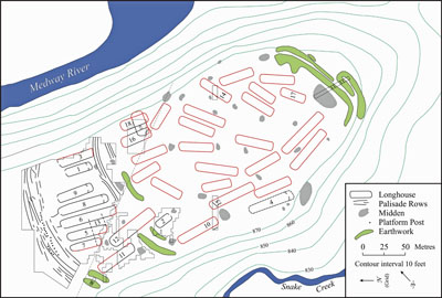
Article
The Lawson site is a two-hectare village occupied by the Neutral Iroquoians circa 1500–25 CE.
"https://d3d0lqu00lnqvz.cloudfront.net/media/media/7bb513b8-0853-4f6e-94b4-3b07c5a48729.jpg" // resources/views/front/categories/view.blade.phphttps://d3d0lqu00lnqvz.cloudfront.net/media/media/7bb513b8-0853-4f6e-94b4-3b07c5a48729.jpg