Article
Public Archives of Canada
See NATIONAL ARCHIVES OF CANADA.
Signing up enhances your TCE experience with the ability to save items to your personal reading list, and access the interactive map.
Create Account"https://www.thecanadianencyclopedia.ca/images/tce_placeholder.jpg?v=e9dca980c9bdb3aa11e832e7ea94f5d9" // resources/views/front/categories/view.blade.phphttps://www.thecanadianencyclopedia.ca/images/tce_placeholder.jpg?v=e9dca980c9bdb3aa11e832e7ea94f5d9

Article
Pugwash, NS, incorporated as a village in 1948, population 744 (2011c), 784 (2006c). Pugwash is located 65 km northwest of TRURO, at the mouth of the Pugwash River.
"https://www.thecanadianencyclopedia.ca/images/tce_placeholder.jpg?v=e9dca980c9bdb3aa11e832e7ea94f5d9" // resources/views/front/categories/view.blade.phphttps://www.thecanadianencyclopedia.ca/images/tce_placeholder.jpg?v=e9dca980c9bdb3aa11e832e7ea94f5d9
Article
Pukaskwa National Park (designated 1978, 1877.8 km2) is bracketed on the west by the coastline of Lake Superior, an impressive stretch of massive headlands and beaches of golden sand or water-worn cobble. The name is of native origin but its meaning is unclear.
"https://d3d0lqu00lnqvz.cloudfront.net/media/media/8fa1ba40-04c8-4e20-b684-d478d83147ff.jpg" // resources/views/front/categories/view.blade.phphttps://d3d0lqu00lnqvz.cloudfront.net/media/media/8fa1ba40-04c8-4e20-b684-d478d83147ff.jpg

"https://d3d0lqu00lnqvz.cloudfront.net/media/media/9b6a1cce-c95d-4cf8-ab82-694169a097f7.jpg" // resources/views/front/categories/view.blade.phphttps://d3d0lqu00lnqvz.cloudfront.net/media/media/9b6a1cce-c95d-4cf8-ab82-694169a097f7.jpg

Article
Qajartalik (pronounced k-eye-yar-tal-ick, meaning “where there is a kayak” in Inuktitut) is the largest and most well-studied site containing evidence of petroglyphs in the Canadian Arctic. Petroglyphs are a type of rock art made by carving directly into a rock panel. Qajartalik is one of only four known sites in the Canadian Arctic and Greenland with petroglyphs. All these petroglyph sites are located on the northeastern coast of the Ungava Peninsula. Based on the artistic style of the carved images, archaeologists believe the Dorset people, also known as the Tuniit in Inuit oral histories, from the latter third of their cultural period made them. This would mean the petroglyphs are roughly 700 to 1,500 years old. Given the large number of petroglyphs, at least 180, Qajartalik was likely an important site to the Dorset people and is one of the most significant archaeological sites in the Arctic.
"https://d3d0lqu00lnqvz.cloudfront.net/qajartalik/Qajartalik.jpg" // resources/views/front/categories/view.blade.phphttps://d3d0lqu00lnqvz.cloudfront.net/qajartalik/Qajartalik.jpg

Article
Qalipu (pronounced: ha-lee-boo) is a Mi’kmaq First Nation based in Newfoundland and Labrador. The nation was established in 2011 under the Indian Act. According to the federal government, Qalipu has 24,464 registered members in 2021, making it the second-largest First Nation by population in Canada. The nation’s members hail from 67 different communities across Newfoundland. As of 2020, roughly 95 per cent of Qalipu members live in Newfoundland and Labrador; the other 5 per cent live throughout Canada. The Qalipu Mi’kmaq First Nation currently controls no reserve land. (See also Reserves in Newfoundland and Labrador.)
"https://d3d0lqu00lnqvz.cloudfront.net/Marc Humber article pic.jpg" // resources/views/front/categories/view.blade.phphttps://d3d0lqu00lnqvz.cloudfront.net/Marc Humber article pic.jpg
Article
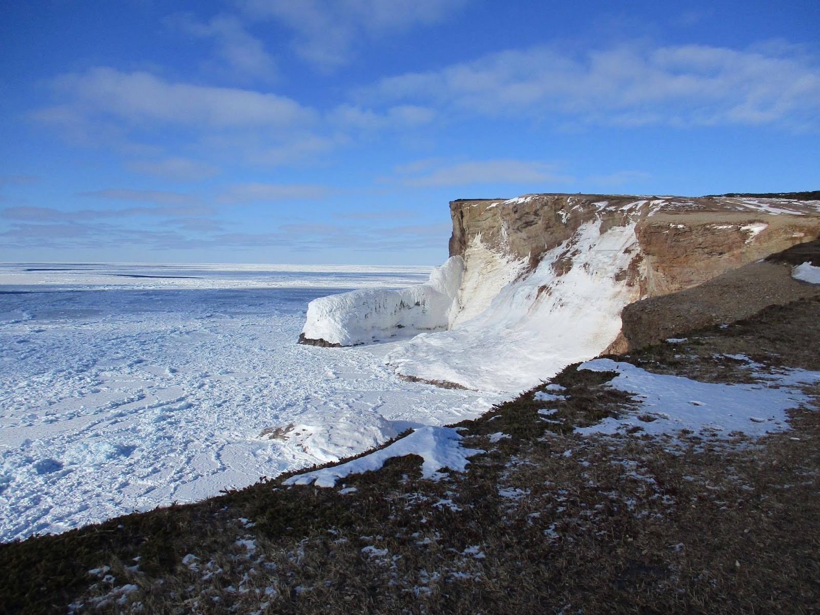
Qausuittuq National Park encompasses 11,000 km2 on northern Bathurst Island and smaller surrounding islands in Nunavut. It also includes the waters of May Inlet and Young Inlet. Pronounced Kow-soo-ee-took, the name of this park translates to “the place where the sun doesn’t rise” in Inuktitut. It is bordered to the south by Polar Bear Pass National Wildlife Area, and together these two zones protect a large, ecologically intact area in the Canadian Arctic Archipelago. Qausuittuq was established on 1 September 2015 as Canada’s 45th national park. It represents the Western High Arctic Natural Region, the 38th natural region of the 39 that constitute Canada’s national parks system.
"https://d3d0lqu00lnqvz.cloudfront.net/media/media/b24f1a0a-425c-40af-87b6-16d3164c5e60.jpg" // resources/views/front/categories/view.blade.phphttps://d3d0lqu00lnqvz.cloudfront.net/media/media/b24f1a0a-425c-40af-87b6-16d3164c5e60.jpg

Article
Quadra Island, BC, 270 km2, is situated at the North end of the Strait of Georgia between Vancouver Island and mainland BC, opposite Campbell River.
"https://www.thecanadianencyclopedia.ca/images/tce_placeholder.jpg?v=e9dca980c9bdb3aa11e832e7ea94f5d9" // resources/views/front/categories/view.blade.phphttps://www.thecanadianencyclopedia.ca/images/tce_placeholder.jpg?v=e9dca980c9bdb3aa11e832e7ea94f5d9
Article
Qualicum Beach, BC, incorporated as a town in 1983, population 8687 (2011c), 8502 (2006c). The Town of Qualicum Beach is located on the east coast of VANCOUVER ISLAND, 48 km north of NANAIMO. The name Qualicum is a Straits Salish (see SALISH, CENTRAL COAST) word meaning "where the dog salmon run.
"https://www.thecanadianencyclopedia.ca/images/tce_placeholder.jpg?v=e9dca980c9bdb3aa11e832e7ea94f5d9" // resources/views/front/categories/view.blade.phphttps://www.thecanadianencyclopedia.ca/images/tce_placeholder.jpg?v=e9dca980c9bdb3aa11e832e7ea94f5d9
Article
The Qu'Appelle River, 430 km long, rises in Lake Diefenbaker and meanders generally east across southern Saskatchewan, joining the Assiniboine River just east of the Manitoba border.
"https://www.thecanadianencyclopedia.ca/images/tce_placeholder.jpg?v=e9dca980c9bdb3aa11e832e7ea94f5d9" // resources/views/front/categories/view.blade.phphttps://www.thecanadianencyclopedia.ca/images/tce_placeholder.jpg?v=e9dca980c9bdb3aa11e832e7ea94f5d9
Article
The Quarry of the Ancestors is a 199-ha area located 48 km north of Fort McMurray, Alberta.
"https://d3d0lqu00lnqvz.cloudfront.net/media/media/cc3c2b00-1574-4756-b032-c6ec3e564c7a.jpg" // resources/views/front/categories/view.blade.phphttps://d3d0lqu00lnqvz.cloudfront.net/media/media/cc3c2b00-1574-4756-b032-c6ec3e564c7a.jpg

Article
Quebec is the largest province in Canada. Its territory represents 15.5 per cent of the surface area of Canada and totals more than 1.5 million km2. Quebec shares borders with Ontario, New Brunswick and Newfoundland. The province also neighbours on four American states: Maine, New Hampshire, Vermont and New York. The name Quebec was inspired by an Algonquian word meaning “where the river narrows.” The French in New France used it solely to refer to the city of Quebec. The British were the first to use the name in a broader sense.
"https://d3d0lqu00lnqvz.cloudfront.net/media/media/98975740-c322-469b-9fe0-d603876f072d.png" // resources/views/front/categories/view.blade.phphttps://d3d0lqu00lnqvz.cloudfront.net/media/media/98975740-c322-469b-9fe0-d603876f072d.png

Timelines
Quebec is the largest Canadian province. At 1.5 million km², its territory accounts for 15.5 per cent of Canada's total area. The province shares borders with Ontario, New Brunswick, and Newfoundland and Labrador.
"https://d3d0lqu00lnqvz.cloudfront.net/media/media/26ba56cd-0975-483e-b342-5b276d9a793e.jpg" // resources/views/front/categories/view.blade.phphttps://d3d0lqu00lnqvz.cloudfront.net/media/media/26ba56cd-0975-483e-b342-5b276d9a793e.jpg

Article
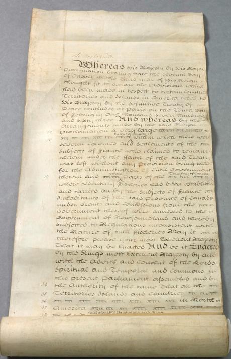
The Quebec Act received royal assent on 22 June 1774. It revoked the Royal Proclamation of 1763, which had aimed to assimilate the French-Canadian population under English rule. The Quebec Act was put into effect on 1 May 1775. It was passed to gain the loyalty of the French-speaking majority of the Province of Quebec. Based on recommendations from Governors James Murray and Guy Carleton, the Act guaranteed the freedom of worship and restored French property rights. However, the Act had dire consequences for Britain’s North American empire. Considered one of the five “Intolerable Acts” by the Thirteen American Colonies, the Quebec Act was one of the direct causes of the American Revolutionary War (1775–83). It was followed by the Constitutional Act in 1791. This is the full-length entry about the Quebec Act of 1774. For a plain language summary, please see The Quebec Act, 1774 (Plain-Language Summary).
"https://d3d0lqu00lnqvz.cloudfront.net/media/media/bcf0dcc3-ce34-4098-8543-00bcccbaabe0.jpg" // resources/views/front/categories/view.blade.phphttps://d3d0lqu00lnqvz.cloudfront.net/media/media/bcf0dcc3-ce34-4098-8543-00bcccbaabe0.jpg
Article
The Citadel has been an active military base since 1920. The Historic Sites and Monuments Board of Canada designated the uneven star-shaped Citadel as a national historic site in 1946 but its importance was recognized much earlier, and it was one of Canada's first heritage conservation projects.
"https://d3d0lqu00lnqvz.cloudfront.net/media/media/a7702171-fde4-4dd7-b794-ee21a1f28b6e.jpg" // resources/views/front/categories/view.blade.phphttps://d3d0lqu00lnqvz.cloudfront.net/media/media/a7702171-fde4-4dd7-b794-ee21a1f28b6e.jpg
