Article
Senneterre
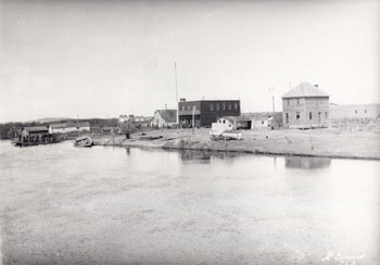
Senneterre, Qué, Town, pop 2993 (2006c), 3275 (2001c), inc 1956. Senneterre is located 130 km east of ROUYN-NORANDA along the banks of the Rivière Bell in Québec's Abitibi-Témiscamingue region. It was
Signing up enhances your TCE experience with the ability to save items to your personal reading list, and access the interactive map.
Create AccountArticle
Senneterre, Qué, Town, pop 2993 (2006c), 3275 (2001c), inc 1956. Senneterre is located 130 km east of ROUYN-NORANDA along the banks of the Rivière Bell in Québec's Abitibi-Témiscamingue region. It was
"https://www.thecanadianencyclopedia.ca/images/tce_placeholder.jpg?v=e9dca980c9bdb3aa11e832e7ea94f5d9" // resources/views/front/categories/view.blade.phphttps://www.thecanadianencyclopedia.ca/images/tce_placeholder.jpg?v=e9dca980c9bdb3aa11e832e7ea94f5d9

Article
During the late 19th and early 20th centuries ranching was the primary activity in the area and from 1910 the ranchers were forced to share the land with grain farmers. In 1913 the CPR extended its line into the area and the Shaunavon site developed.
"https://www.thecanadianencyclopedia.ca/images/tce_placeholder.jpg?v=e9dca980c9bdb3aa11e832e7ea94f5d9" // resources/views/front/categories/view.blade.phphttps://www.thecanadianencyclopedia.ca/images/tce_placeholder.jpg?v=e9dca980c9bdb3aa11e832e7ea94f5d9
Article
The name Shawinigan, of Algonquin origin, means "portage on the crest." This refers to the crest of rocks that had to be climbed in order to portage around the majestic waterfall.
"https://d3d0lqu00lnqvz.cloudfront.net/media/media/ea5fd025-22d0-40e2-9ee2-572d9a1f30f4.jpg" // resources/views/front/categories/view.blade.phphttps://d3d0lqu00lnqvz.cloudfront.net/media/media/ea5fd025-22d0-40e2-9ee2-572d9a1f30f4.jpg

Article
Shediac, NB, incorporated as a town in 1903, population 6053 (2011c), 5497 (2006c). The Town of Shediac is located on Northumberland Strait, 20 km east of MONCTON.
"https://d3d0lqu00lnqvz.cloudfront.net/media/media/79b00de0-c5fb-45bb-845c-10eedba8ac81.jpg" // resources/views/front/categories/view.blade.phphttps://d3d0lqu00lnqvz.cloudfront.net/media/media/79b00de0-c5fb-45bb-845c-10eedba8ac81.jpg

Article
Shelburne, NS, incorporated as a town in 1907, population 1686 (2011c), 1879 (2006c). The Town of Shelburne, the seat of Shelburne County, is located on Shelburne Harbour 208 km southwest of Halifax.
"https://d3d0lqu00lnqvz.cloudfront.net/media/media/c753ddd6-20d5-44c3-9c7e-80a07b3f6bf1.jpg" // resources/views/front/categories/view.blade.phphttps://d3d0lqu00lnqvz.cloudfront.net/media/media/c753ddd6-20d5-44c3-9c7e-80a07b3f6bf1.jpg

Article
Shellbrook is located near the northern edge of agricultural settlement in Saskatchewan. Its first homesteaders did not arrive until the late 19th century. Much of the land was covered by jack pine which had to be cleared before crops could be planted.
"https://d3d0lqu00lnqvz.cloudfront.net/media/media/d89a508e-6a18-4e5d-8dd1-b2e744a7af23.jpg" // resources/views/front/categories/view.blade.phphttps://d3d0lqu00lnqvz.cloudfront.net/media/media/d89a508e-6a18-4e5d-8dd1-b2e744a7af23.jpg

Article
Shippagan, NB, incorporated as a town in 1958, population 2603 (2011c), 2754 (2006c). The Town of Shippagan is located at the extreme northeastern point of mainland New Brunswick.
"https://www.thecanadianencyclopedia.ca/images/tce_placeholder.jpg?v=e9dca980c9bdb3aa11e832e7ea94f5d9" // resources/views/front/categories/view.blade.phphttps://www.thecanadianencyclopedia.ca/images/tce_placeholder.jpg?v=e9dca980c9bdb3aa11e832e7ea94f5d9
Article
Sidney, BC, incorporated as a town in 1967, population 11 178 (2011c), 11 315 (2006c). The Town of Sidney is located on the east side of the SAANICH PENINSULA on Vancouver Island, 30 km north of VICTORIA, facing Haro Strait.
"https://www.thecanadianencyclopedia.ca/images/tce_placeholder.jpg?v=e9dca980c9bdb3aa11e832e7ea94f5d9" // resources/views/front/categories/view.blade.phphttps://www.thecanadianencyclopedia.ca/images/tce_placeholder.jpg?v=e9dca980c9bdb3aa11e832e7ea94f5d9
Article
Some 500 Ojibwa currently live on the nearby Whitefish Bay Reserve. European settlement dates from the late 1920s, although previously there were numerous lumber camps in the area.
"https://www.thecanadianencyclopedia.ca/images/tce_placeholder.jpg?v=e9dca980c9bdb3aa11e832e7ea94f5d9" // resources/views/front/categories/view.blade.phphttps://www.thecanadianencyclopedia.ca/images/tce_placeholder.jpg?v=e9dca980c9bdb3aa11e832e7ea94f5d9
Article
Slave Lake, Alberta, incorporated as a town in 1965, population 6,651 (2016 census), 6,782 (2011 census). The town of Slave Lake is about two kilometres from the southeastern shore of Lesser Slave Lake.
"https://d3d0lqu00lnqvz.cloudfront.net/media/media/04d79109-7d09-494b-943b-1d5a62085ec2.jpg" // resources/views/front/categories/view.blade.phphttps://d3d0lqu00lnqvz.cloudfront.net/media/media/04d79109-7d09-494b-943b-1d5a62085ec2.jpg
Article
Smithers, British Columbia, incorporated as a town in 1967, population 5,401 (2016 census), 5,404 (2011 census). The town of Smithers is located on the Bulkley River in central BC, on Highway 16. The town is 334 km west of Prince George and 371 km east of Prince Rupert.
"https://www.thecanadianencyclopedia.ca/images/tce_placeholder.jpg?v=e9dca980c9bdb3aa11e832e7ea94f5d9" // resources/views/front/categories/view.blade.phphttps://www.thecanadianencyclopedia.ca/images/tce_placeholder.jpg?v=e9dca980c9bdb3aa11e832e7ea94f5d9
Article
Smiths Falls, ON, incorporated as a town in 1882, population 9,254 (2021 census), 8,780 (2016 census). The Town of Smiths Falls is located on the Rideau River, 60 km southwest of Ottawa. The town is an important lockport on the waterway.
"https://www.thecanadianencyclopedia.ca/images/tce_placeholder.jpg?v=e9dca980c9bdb3aa11e832e7ea94f5d9" // resources/views/front/categories/view.blade.phphttps://www.thecanadianencyclopedia.ca/images/tce_placeholder.jpg?v=e9dca980c9bdb3aa11e832e7ea94f5d9
Article
Snow Lake, Manitoba, incorporated as a town in 1976, population 723 (2011c), 837 (2006c). The Town of Snow Lake is located 679 km northwest of Winnipeg on the Canadian SHIELD.
"https://www.thecanadianencyclopedia.ca/images/tce_placeholder.jpg?v=e9dca980c9bdb3aa11e832e7ea94f5d9" // resources/views/front/categories/view.blade.phphttps://www.thecanadianencyclopedia.ca/images/tce_placeholder.jpg?v=e9dca980c9bdb3aa11e832e7ea94f5d9
Article
Souris, Manitoba, incorporated as a town in 1903, population 1837 (2011c), 1772 (2006c). The Town of Souris is located at the junction of Plum Creek and the SOURIS RIVER, 45 km by road southwest of Brandon.
"https://www.thecanadianencyclopedia.ca/images/tce_placeholder.jpg?v=e9dca980c9bdb3aa11e832e7ea94f5d9" // resources/views/front/categories/view.blade.phphttps://www.thecanadianencyclopedia.ca/images/tce_placeholder.jpg?v=e9dca980c9bdb3aa11e832e7ea94f5d9
Article
Souris, Prince Edward Island, incorporated as a town in 1910, population 1,079 (2021 census), 1,053 (2016 census). Located in Kings County in the northeastern portion of PEI, the town is situated along Colville Bay at the mouth of the Souris River. Due to the orientation of its port, there is minimal fast ice (ice anchored to the shore) in the harbour. Additionally, it is strategically close to major shipping routes, and it is PEI’s nearest practical port with the shortest sea voyage to both sides of the Atlantic. Souris has been the location of the interprovincial ferry terminal for the service to Quebec’s Magdalen Islands since 1971.
"https://d3d0lqu00lnqvz.cloudfront.net/souris/lighthouse.jpg" // resources/views/front/categories/view.blade.phphttps://d3d0lqu00lnqvz.cloudfront.net/souris/lighthouse.jpg
