Article
Salmo
Salmo, BC, incorporated as a village in 1946, population 1139 (2011c), 1007 (2006c). The Village of Salmo is located in the Selkirk Mountains on the Salmo River at its junction with Erie Creek, 24 km north of the United States border.
Signing up enhances your TCE experience with the ability to save items to your personal reading list, and access the interactive map.
Create AccountArticle
Salmo, BC, incorporated as a village in 1946, population 1139 (2011c), 1007 (2006c). The Village of Salmo is located in the Selkirk Mountains on the Salmo River at its junction with Erie Creek, 24 km north of the United States border.
"https://www.thecanadianencyclopedia.ca/images/tce_placeholder.jpg?v=e9dca980c9bdb3aa11e832e7ea94f5d9" // resources/views/front/categories/view.blade.phphttps://www.thecanadianencyclopedia.ca/images/tce_placeholder.jpg?v=e9dca980c9bdb3aa11e832e7ea94f5d9

Article
Salmon Arm, British Columbia, incorporated as a city in 2005, population 17,706 (2016 census), 17,464 (2011 census). The city of Salmon Arm is located at the head of the southwestern arm of Shuswap Lake, also called Salmon Arm, 110 km east of Kamloops.
"https://d3d0lqu00lnqvz.cloudfront.net/media/media/13d5ba26-c992-4341-99fa-c71c6fe1dc4f.jpg" // resources/views/front/categories/view.blade.phphttps://d3d0lqu00lnqvz.cloudfront.net/media/media/13d5ba26-c992-4341-99fa-c71c6fe1dc4f.jpg

Article
Silver was found in 1891 and a rush followed, with thousands of prospectors staking the silver-bearing slopes. By 1895 Sandon was a thriving town and the terminus of 2 railways.
"https://www.thecanadianencyclopedia.ca/images/tce_placeholder.jpg?v=e9dca980c9bdb3aa11e832e7ea94f5d9" // resources/views/front/categories/view.blade.phphttps://www.thecanadianencyclopedia.ca/images/tce_placeholder.jpg?v=e9dca980c9bdb3aa11e832e7ea94f5d9
Article
Sanikiluaq, Nunavut, incorporated as a hamlet in 1976, population 812 (2011c), 744 (2006c).
"https://www.thecanadianencyclopedia.ca/images/tce_placeholder.jpg?v=e9dca980c9bdb3aa11e832e7ea94f5d9" // resources/views/front/categories/view.blade.phphttps://www.thecanadianencyclopedia.ca/images/tce_placeholder.jpg?v=e9dca980c9bdb3aa11e832e7ea94f5d9
Article
Sarnia, Ontario, incorporated as a city in 1914, population 71,594 (2016 c), 72,366 (2011 c). The City of Sarnia is located at the convergence of the St. Clair River and Lake Huron, 100 km west of London. A railway tunnel beneath the St. Clair and a highway bridge from nearby Point Edward connect Sarnia with Port Huron, Michigan. Sarnia is a major centre for the petrochemical industry and the southern terminus of an oil pipeline from Alberta. It was also the home of Alexander Mackenzie, first Liberal prime minister of Canada.
"https://d3d0lqu00lnqvz.cloudfront.net/media/media/35d2cb6f-0ea1-4258-9795-68b7ab247e24.jpg" // resources/views/front/categories/view.blade.phphttps://d3d0lqu00lnqvz.cloudfront.net/media/media/35d2cb6f-0ea1-4258-9795-68b7ab247e24.jpg

Article
Saskatoon, Saskatchewan, incorporated as a city in 1906, population 266,141 (2021 census), 247,201 (2016 census). The City of Saskatoon, the largest city in Saskatchewan, is situated in rolling parklands on the banks of the northward-flowing South Saskatchewan River, 352 km northwest of Regina. It serves as regional centre for the northern prairies and for central and northern Saskatchewan. It is noted for its extensive riverbank parks and trails, wide tree-lined streets and attractive University of Saskatchewan campus.
"https://d3d0lqu00lnqvz.cloudfront.net/media/media/c4ed4d03-e017-484f-b344-935c8f3295e8.jpg" // resources/views/front/categories/view.blade.phphttps://d3d0lqu00lnqvz.cloudfront.net/media/media/c4ed4d03-e017-484f-b344-935c8f3295e8.jpg

Article
Sault Ste Marie, Ontario, incorporated as a town in 1887 and as a city in 1912, population 72,051 (2021 census), 73,368 (2016 census). The city of Sault Ste Marie is located adjacent to the rapids of the St Marys River between lakes Superior and Huron. Across the river is the American city of the same name. Sault Ste Marie sits on the traditional territory of the Ojibwe, who called the site Bawating (“place of the rapids”) and valued it for its access to the upper Great Lakes and as a source of abundant whitefish and maple sugar. It is popularly called “the Sault,” or “Soo.”
"https://d3d0lqu00lnqvz.cloudfront.net/media/media/a1557c26-bfa4-48ad-aef1-724137f63990.jpg" // resources/views/front/categories/view.blade.phphttps://d3d0lqu00lnqvz.cloudfront.net/media/media/a1557c26-bfa4-48ad-aef1-724137f63990.jpg

Article
Scarborough, Ontario, former municipality, now a part of the city of Toronto. Scarborough is located on Lake Ontario and makes up the eastern part of the city. It was incorporated as a township in 1850 and as a city in 1983. In 1998, the provincial government, under the leadership of Premier Mike Harris, amalgamated six municipalities — Etobicoke, York, East York, North York, Scarborough and Toronto — to form the City of Toronto, a single municipality.
"https://d3d0lqu00lnqvz.cloudfront.net/media/media/f108614c-795e-4be6-a573-a66025a1a7e8.jpg" // resources/views/front/categories/view.blade.phphttps://d3d0lqu00lnqvz.cloudfront.net/media/media/f108614c-795e-4be6-a573-a66025a1a7e8.jpg

Article
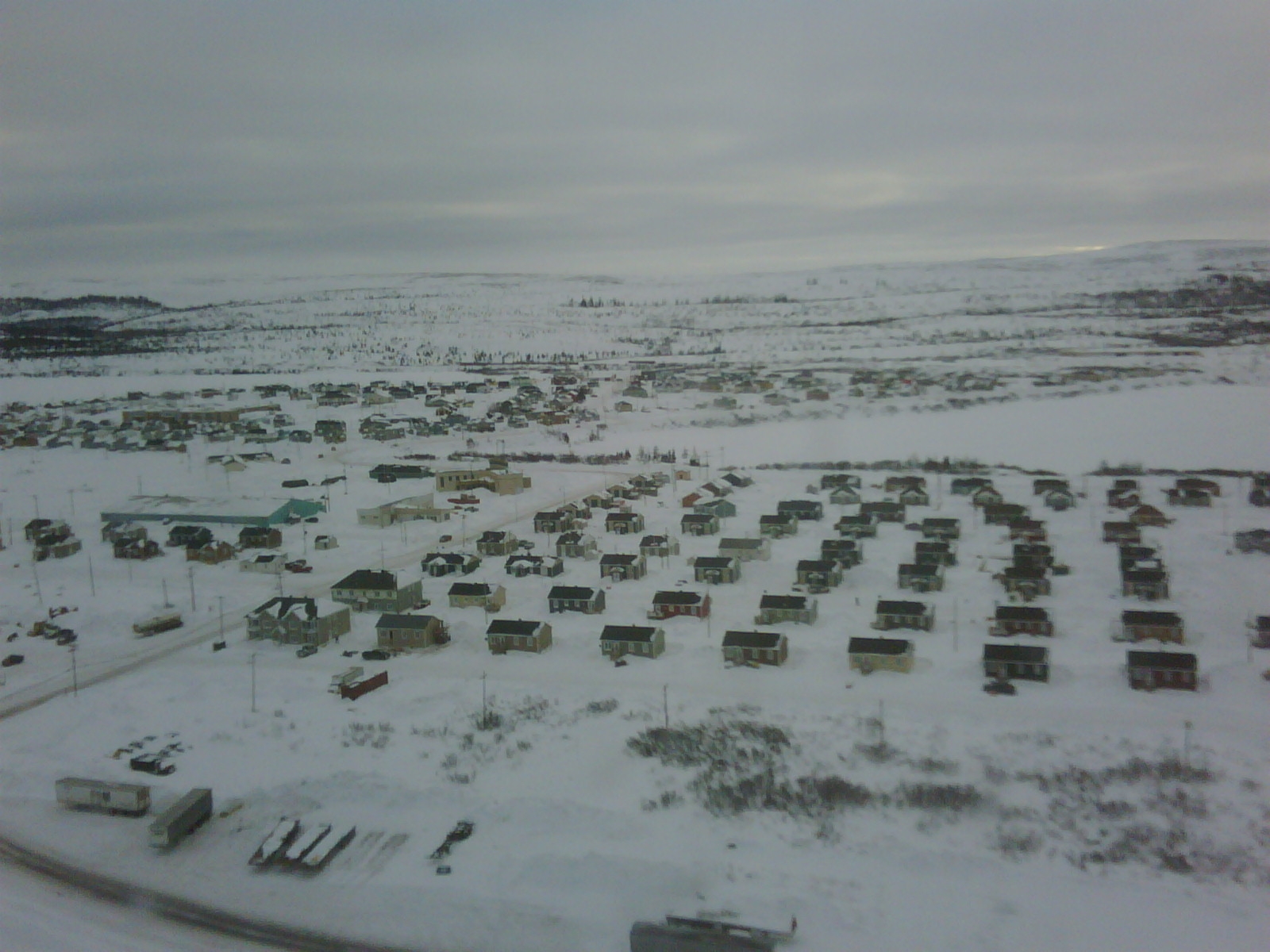
Schefferville, Quebec, incorporated as a town in 1955, population 155 (2016 census), 213 (2011 census). Schefferville is located between Knob and Pearce Lakes, on Quebec’s border with Labrador, 510 km north of Sept-Îles.
"https://d3d0lqu00lnqvz.cloudfront.net/media/new_article_images/Schefferville/Schefferville_2013.jpg" // resources/views/front/categories/view.blade.phphttps://d3d0lqu00lnqvz.cloudfront.net/media/new_article_images/Schefferville/Schefferville_2013.jpg
Article
Sechelt, BC, incorporated as a district municipality in 1986, population 9291 (2011c), 8454 (2006c). The District of Sechelt is located on the Sunshine Coast of British Columbia north of Vancouver on the Strait of GEORGIA. The community is named for the Sechelt who inhabit the area.
"https://d3d0lqu00lnqvz.cloudfront.net/media/media/d6cba941-1fb0-4c1a-98b3-2eb3969ed279.jpg" // resources/views/front/categories/view.blade.phphttps://d3d0lqu00lnqvz.cloudfront.net/media/media/d6cba941-1fb0-4c1a-98b3-2eb3969ed279.jpg

Article
The Sechelt Peninsula, approximately 350 km2, is part of a popular cottage area and yachting centre in British Columbia known as the "Sunshine Coast." Isolated from nearby Vancouver, BC, by Howe Sound and the Coast Mountains, its coast is linked by ferries with Vancouver via Horseshoe Bay and with Powell River via Saltery Bay.
"https://d3d0lqu00lnqvz.cloudfront.net/media/media/4a729b12-6f87-42d2-914e-96163d8c8ce3.jpg" // resources/views/front/categories/view.blade.phphttps://d3d0lqu00lnqvz.cloudfront.net/media/media/4a729b12-6f87-42d2-914e-96163d8c8ce3.jpg

Article
Selkirk, Manitoba, incorporated as a town in 1882 and as a city in 1998, population 10,504 (2021 census), 10,278 (2016 census). The City of Selkirk is located on the west bank of the Red River, 29 km north of Winnipeg. The city was named after Thomas Douglas, Fifth Earl of Selkirk.
"https://thecanadianencyclopedia.ca/images/tce_placeholder.jpg?v=e9dca980c9bdb3aa11e832e7ea94f5d9" // resources/views/front/categories/view.blade.phphttps://thecanadianencyclopedia.ca/images/tce_placeholder.jpg?v=e9dca980c9bdb3aa11e832e7ea94f5d9

Article
Senneterre, Qué, Town, pop 2993 (2006c), 3275 (2001c), inc 1956. Senneterre is located 130 km east of ROUYN-NORANDA along the banks of the Rivière Bell in Québec's Abitibi-Témiscamingue region. It was
"https://www.thecanadianencyclopedia.ca/images/tce_placeholder.jpg?v=e9dca980c9bdb3aa11e832e7ea94f5d9" // resources/views/front/categories/view.blade.phphttps://www.thecanadianencyclopedia.ca/images/tce_placeholder.jpg?v=e9dca980c9bdb3aa11e832e7ea94f5d9
Article
The first permanent European settlement dates from 1651: the Ange-Gardien mission founded by Father Jean de Quen. A trading and fishing post set up there in 1676 by Louis Jolliet was ceded in the 19th century to the Hudson's Bay Company.
"https://d3d0lqu00lnqvz.cloudfront.net/media/media/b58f3f0e-84bf-496f-92f5-a676522afa6c.jpg" // resources/views/front/categories/view.blade.phphttps://d3d0lqu00lnqvz.cloudfront.net/media/media/b58f3f0e-84bf-496f-92f5-a676522afa6c.jpg

Article
Sexsmith, Alta, incorporated as a village in 1929 and as a town in 1979, population 2418 (2011c), 1969 (2006c). The Town of Sexsmith is 43 km north of GRANDE PRAIRIE on Highway 2. The district was first settled in 1911, with a post office called Sexsmith established in 1912.
"https://d3d0lqu00lnqvz.cloudfront.net/media/media/fb6ef2de-ba1b-4446-8c02-467e561b7fe5.jpg" // resources/views/front/categories/view.blade.phphttps://d3d0lqu00lnqvz.cloudfront.net/media/media/fb6ef2de-ba1b-4446-8c02-467e561b7fe5.jpg
