Article
Province House, Charlottetown
Province House in Charlottetown is the home of Prince Edward Island's Legislative Assembly.
Signing up enhances your TCE experience with the ability to save items to your personal reading list, and access the interactive map.
Create AccountArticle
Province House in Charlottetown is the home of Prince Edward Island's Legislative Assembly.
"https://www.thecanadianencyclopedia.ca/images/tce_placeholder.jpg?v=e9dca980c9bdb3aa11e832e7ea94f5d9" // resources/views/front/categories/view.blade.phphttps://www.thecanadianencyclopedia.ca/images/tce_placeholder.jpg?v=e9dca980c9bdb3aa11e832e7ea94f5d9

Article
Qajartalik (pronounced k-eye-yar-tal-ick, meaning “where there is a kayak” in Inuktitut) is the largest and most well-studied site containing evidence of petroglyphs in the Canadian Arctic. Petroglyphs are a type of rock art made by carving directly into a rock panel. Qajartalik is one of only four known sites in the Canadian Arctic and Greenland with petroglyphs. All these petroglyph sites are located on the northeastern coast of the Ungava Peninsula. Based on the artistic style of the carved images, archaeologists believe the Dorset people, also known as the Tuniit in Inuit oral histories, from the latter third of their cultural period made them. This would mean the petroglyphs are roughly 700 to 1,500 years old. Given the large number of petroglyphs, at least 180, Qajartalik was likely an important site to the Dorset people and is one of the most significant archaeological sites in the Arctic.
"https://d3d0lqu00lnqvz.cloudfront.net/qajartalik/Qajartalik.jpg" // resources/views/front/categories/view.blade.phphttps://d3d0lqu00lnqvz.cloudfront.net/qajartalik/Qajartalik.jpg

Article
The Quarry of the Ancestors is a 199-ha area located 48 km north of Fort McMurray, Alberta.
"https://d3d0lqu00lnqvz.cloudfront.net/media/media/cc3c2b00-1574-4756-b032-c6ec3e564c7a.jpg" // resources/views/front/categories/view.blade.phphttps://d3d0lqu00lnqvz.cloudfront.net/media/media/cc3c2b00-1574-4756-b032-c6ec3e564c7a.jpg

Article
The Citadel has been an active military base since 1920. The Historic Sites and Monuments Board of Canada designated the uneven star-shaped Citadel as a national historic site in 1946 but its importance was recognized much earlier, and it was one of Canada's first heritage conservation projects.
"https://d3d0lqu00lnqvz.cloudfront.net/media/media/a7702171-fde4-4dd7-b794-ee21a1f28b6e.jpg" // resources/views/front/categories/view.blade.phphttps://d3d0lqu00lnqvz.cloudfront.net/media/media/a7702171-fde4-4dd7-b794-ee21a1f28b6e.jpg

Article
The Quidi Vidi Battery was built in 1762 by the French. The French attacked the ST JOHN'S, Nfld, area in one of the last campaigns of the SEVEN YEARS' WAR, capturing and burning many settlements around Trinity and Conception bays. They then erected the battery to defend their newly won territory.
"https://www.thecanadianencyclopedia.ca/images/tce_placeholder.jpg?v=e9dca980c9bdb3aa11e832e7ea94f5d9" // resources/views/front/categories/view.blade.phphttps://www.thecanadianencyclopedia.ca/images/tce_placeholder.jpg?v=e9dca980c9bdb3aa11e832e7ea94f5d9
Article
The Rainy River Burial Mounds archaeological sites are located on the Canadian bank of the Rainy River in Ontario.
"https://www.thecanadianencyclopedia.ca/images/tce_placeholder.jpg?v=e9dca980c9bdb3aa11e832e7ea94f5d9" // resources/views/front/categories/view.blade.phphttps://www.thecanadianencyclopedia.ca/images/tce_placeholder.jpg?v=e9dca980c9bdb3aa11e832e7ea94f5d9
Article
The Rat Indian Creek site is located above the Arctic Circle, on the Porcupine River, 60 km east of the Vuntut Gwitchin village of Old Crow, Yukon.
"https://d3d0lqu00lnqvz.cloudfront.net/media/media/891e3d37-3191-4b19-900a-76e3eb2be918.jpg" // resources/views/front/categories/view.blade.phphttps://d3d0lqu00lnqvz.cloudfront.net/media/media/891e3d37-3191-4b19-900a-76e3eb2be918.jpg

Article
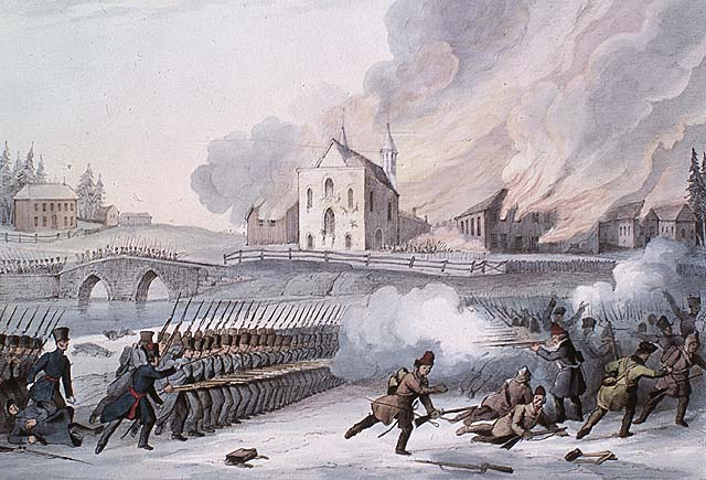
In 1837 and 1838, French Canadian militants in Lower Canada took up arms against the British Crown in a pair of insurrections. The twin rebellions killed more than 300 people. They followed years of tensions between the colony’s anglophone minority and the growing, nationalistic aspirations of its francophone majority. The rebels failed in their campaign against British rule. However, their revolt led to political reform, including the unified Province of Canada and the introduction of responsible government. The rebellion in Lower Canada, which is also known as the Patriots' War (la Guerre des patriotes), also gave French Canadians one of their first nationalist heroes in Louis-Joseph Papineau.
"https://d3d0lqu00lnqvz.cloudfront.net/media/media/37aadc48-3f88-4946-a9aa-0d2ad30495cd.jpg" // resources/views/front/categories/view.blade.phphttps://d3d0lqu00lnqvz.cloudfront.net/media/media/37aadc48-3f88-4946-a9aa-0d2ad30495cd.jpg
Article
The 1837 rebellion in Upper Canada was a less violent, more limited affair than the uprising earlier that year in Lower Canada. However, its leaders, including William Lyon Mackenzie, were equally serious in their demands. They wanted democratic reform and an end to the rule of a privileged oligarchy. The rebellion itself failed, but its very failure helped pave the way for moderate and careful political change in British North America. This included the union of Upper and Lower Canada into the Province of Canada and the eventual introduction of responsible government.
"https://d3d0lqu00lnqvz.cloudfront.net/media/media/e89570fd-5967-4c63-906b-bfbfab2e39fb.jpg" // resources/views/front/categories/view.blade.phphttps://d3d0lqu00lnqvz.cloudfront.net/media/media/e89570fd-5967-4c63-906b-bfbfab2e39fb.jpg

Article
Red Bay, located on the north shore of the Strait of Belle Isle, Labrador, is an archaeological reference for the 16th-century transatlantic fishery, particularly for Basque whaling activities. After research into Spanish documents and archaeological finds on Saddle Island and under water, Red Bay was designated a historical site in 1978-79. In 2013, the whaling station at Red Bay was designated a UNESCO World Heritage Site.
"https://d3d0lqu00lnqvz.cloudfront.net/media/media/2d045c80-3539-44a1-a87c-7b1a734b8c91.jpg" // resources/views/front/categories/view.blade.phphttps://d3d0lqu00lnqvz.cloudfront.net/media/media/2d045c80-3539-44a1-a87c-7b1a734b8c91.jpg

Article
The Red River Resistance (also known as the Red River Rebellion) was an uprising in 1869–70 in the Red River Colony. The resistance was sparked by the transfer of the vast territory of Rupert’s Land to the new Dominion of Canada. The colony of farmers and hunters, many of them Métis, occupied a corner of Rupert’s Land and feared for their culture and land rights under Canadian control. The Métis mounted a resistance and declared a provisional government to negotiate terms for entering Confederation. The uprising led to the creation of the province of Manitoba, and the emergence of Métis leader Louis Riel — a hero to his people and many in Quebec, but an outlaw in the eyes of the Canadian government.
"https://d3d0lqu00lnqvz.cloudfront.net/media/media/f0a1f84f-c420-4038-8815-42587e295b75.jpg" // resources/views/front/categories/view.blade.phphttps://d3d0lqu00lnqvz.cloudfront.net/media/media/f0a1f84f-c420-4038-8815-42587e295b75.jpg

Article
Rocky Mountain House National Historic Site, near Rocky Mountain House, Alberta, commemorates a series of fur-trade posts built between 1799 and 1864 by the North West Co and the Hudson's Bay Co (HBC) near the junction of the North Saskatchewan and Clearwater rivers.
"https://www.thecanadianencyclopedia.ca/images/tce_placeholder.jpg?v=e9dca980c9bdb3aa11e832e7ea94f5d9" // resources/views/front/categories/view.blade.phphttps://www.thecanadianencyclopedia.ca/images/tce_placeholder.jpg?v=e9dca980c9bdb3aa11e832e7ea94f5d9
Article
Ross Farm, at New Ross, NS, 28 km north of Chester, dates from 1816, when Captain William Ross led 172 disbanded soldiers into the Nova Scotia interior to establish an agricultural settlement.
"https://www.thecanadianencyclopedia.ca/images/tce_placeholder.jpg?v=e9dca980c9bdb3aa11e832e7ea94f5d9" // resources/views/front/categories/view.blade.phphttps://www.thecanadianencyclopedia.ca/images/tce_placeholder.jpg?v=e9dca980c9bdb3aa11e832e7ea94f5d9
Article
The Ross-Thomson House is located in SHELBURNE, NS. At the end of the American Revolution, thousands of LOYALISTS arrived in Shelburne. Many quickly left, but others, like George and Robert Ross, settled and began businesses in the new town.
"https://www.thecanadianencyclopedia.ca/images/tce_placeholder.jpg?v=e9dca980c9bdb3aa11e832e7ea94f5d9" // resources/views/front/categories/view.blade.phphttps://www.thecanadianencyclopedia.ca/images/tce_placeholder.jpg?v=e9dca980c9bdb3aa11e832e7ea94f5d9
Article
Rutherford House is an elegant Edwardian house built in 1909 for Alexander Cameron RUTHERFORD, the first premier of Alberta and chancellor of the UNIVERSITY OF ALBERTA (1927-41).
"https://www.thecanadianencyclopedia.ca/images/tce_placeholder.jpg?v=e9dca980c9bdb3aa11e832e7ea94f5d9" // resources/views/front/categories/view.blade.phphttps://www.thecanadianencyclopedia.ca/images/tce_placeholder.jpg?v=e9dca980c9bdb3aa11e832e7ea94f5d9