Timelines
Nova Scotia
Nova Scotia is Canada’s second-smallest province (following Prince Edward Island) and is located on the southeastern coast of the country. The province includes Cape Breton, a large island northeast of the mainland.
Signing up enhances your TCE experience with the ability to save items to your personal reading list, and access the interactive map.
Create AccountTimelines
Nova Scotia is Canada’s second-smallest province (following Prince Edward Island) and is located on the southeastern coast of the country. The province includes Cape Breton, a large island northeast of the mainland.
"https://d3d0lqu00lnqvz.cloudfront.net/media/media/251d5ad1-fbf2-4c53-a29e-57df6917949f.jpg" // resources/views/front/categories/view.blade.phphttps://d3d0lqu00lnqvz.cloudfront.net/media/media/251d5ad1-fbf2-4c53-a29e-57df6917949f.jpg
Article
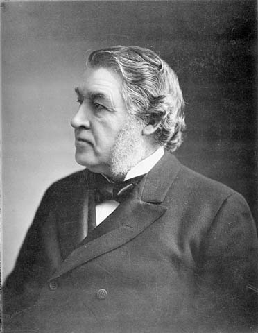
Nova Scotia was one of the four founding provinces of Canada. It joined New Brunswick, Ontario and Quebec in Confederation on 1 July 1867. However, this was mainly because Confederation delivered the Intercolonial Railway to the Maritimes, and because of the efforts of Sir Charles Tupper. His government passed approval for Confederation in the colonial legislature despite popular opposition. (See Confederation’s Opponents.) Confederation was met with mass protests in the colony. Joseph Howe led a two-year effort to repeal the union. (See Repeal Movement.) But Howe finally decided he could do more to help his province by working inside the federal government. He joined the federal Cabinet in 1869.
"https://d3d0lqu00lnqvz.cloudfront.net/media/media/7b457631-bb6e-40ee-bf61-fab12a06fb6d.jpg" // resources/views/front/categories/view.blade.phphttps://d3d0lqu00lnqvz.cloudfront.net/media/media/7b457631-bb6e-40ee-bf61-fab12a06fb6d.jpg
Article
Nueltin Lake, 2279 km2, elev 278 m, max length 144 km, is located on the border of Nunavut and northeastern Manitoba, about 660 km south of the Arctic Circle. An irregularly shaped lake, it has a heavily indented shoreline and contains numerous small islands.
"https://www.thecanadianencyclopedia.ca/images/tce_placeholder.jpg?v=e9dca980c9bdb3aa11e832e7ea94f5d9" // resources/views/front/categories/view.blade.phphttps://www.thecanadianencyclopedia.ca/images/tce_placeholder.jpg?v=e9dca980c9bdb3aa11e832e7ea94f5d9

"https://www.thecanadianencyclopedia.ca/images/tce_placeholder.jpg?v=e9dca980c9bdb3aa11e832e7ea94f5d9" // resources/views/front/categories/view.blade.phphttps://www.thecanadianencyclopedia.ca/images/tce_placeholder.jpg?v=e9dca980c9bdb3aa11e832e7ea94f5d9
Article
Nunatsiavut (meaning “our beautiful land” in Inuktitut) is the homeland of the Labrador Inuit (Labradormiut). The territory covers 72,520km2 of land and 44,030km2 of sea in the northern part of the Labrador Peninsula. On 1 December 2005, the Labrador Inuit celebrated the creation of the Nunatsiavut Government, their own regional government within the province of Newfoundland and Labrador. The Labradormiut became the first Inuit in Canada to achieve self-government. Of the approximately 6,500 beneficiaries, about 2,500 live within the settlement area in five communities: Rigolet, Postville, Makkovik, Hopedale (the legislative capital) and Nain (the administrative capital).
"https://d3d0lqu00lnqvz.cloudfront.net/media/new_article_images/Nunatsiavut/Nunatsiavut_flag.png" // resources/views/front/categories/view.blade.phphttps://d3d0lqu00lnqvz.cloudfront.net/media/new_article_images/Nunatsiavut/Nunatsiavut_flag.png

Article
Nunavik, the portion of land within the province of Quebec located north of the 55th parallel, covers approximately 500,000 km2 (representing more than one-third of Quebec’s territory). For approximately 4,000 years, Indigenous people have inhabited Nunavik, including Inuit who have made the region their homeland. Today, over 13,000 people live in Nunavik’s 14 villages spread along the Ungava Bay, Hudson Strait and Eastern Hudson Bay coasts.
"https://www.thecanadianencyclopedia.ca/images/tce_placeholder.jpg?v=e9dca980c9bdb3aa11e832e7ea94f5d9" // resources/views/front/categories/view.blade.phphttps://www.thecanadianencyclopedia.ca/images/tce_placeholder.jpg?v=e9dca980c9bdb3aa11e832e7ea94f5d9
Article
Nunavut, or “Our Land” in Inuktitut, encompasses over 2 million km2 and has a population of 36,858 residents (2021 census), 30,865 of whom are Inuit. Covering roughly the part of the Canadian mainland and Arctic Archipelago that lies to the north and northeast of the treeline, Nunavut is the largest and northernmost territory of Canada and the fifth largest administrative division in the world. Nunavummiut live in 25 communities spread across this vast territory, with the largest number, 7,429 (2021 census), in the capital, Iqaluit. The creation of Nunavut in 1999 (the region was previously part of the Northwest Territories) represented the first major change to the political map of Canada since the incorporation of Newfoundland into Confederation in 1949. Beyond changing the internal political boundaries of Canada, Nunavut’s formation represented a moment of great political significance; through political activism and long-term negotiations, a small, marginalized Indigenous group overcame many obstacles to peacefully establish a government that they controlled within the Canadian state, thereby gaining control of their land, their resources and their future. As such, the creation of Nunavut represents a landmark moment in the evolution of Canada and a significant development in the history of the world’s Indigenous peoples.
"https://d3d0lqu00lnqvz.cloudfront.net/media/media/b9f1e62c-f97e-49dc-ad8f-ef525846081d.jpg" // resources/views/front/categories/view.blade.phphttps://d3d0lqu00lnqvz.cloudfront.net/media/media/b9f1e62c-f97e-49dc-ad8f-ef525846081d.jpg

Timelines
Nunavut, which translates from the Inuktitut dialect of the Eastern Arctic Inuit as "Our Land," is a Canadian territory.
"https://d3d0lqu00lnqvz.cloudfront.net/media/media/a4b74f70-c61f-4cfe-a857-0848e3cb40bd.jpg" // resources/views/front/categories/view.blade.phphttps://d3d0lqu00lnqvz.cloudfront.net/media/media/a4b74f70-c61f-4cfe-a857-0848e3cb40bd.jpg

Article
Oak Bay, incorporated as a district municipality in 1906, population 18 015 (2011c), 17 908 (2006c). The District of Oak Bay is located on the southeast corner of VANCOUVER ISLAND, adjoining the city of VICTORIA. It is surrounded by JUAN DE FUCA STRAIT on the south and Haro Strait on the east.
"https://www.thecanadianencyclopedia.ca/images/tce_placeholder.jpg?v=e9dca980c9bdb3aa11e832e7ea94f5d9" // resources/views/front/categories/view.blade.phphttps://www.thecanadianencyclopedia.ca/images/tce_placeholder.jpg?v=e9dca980c9bdb3aa11e832e7ea94f5d9
Article
In 1795, 16-year-old Daniel McGinnis discovered a depression in the ground near a huge oak tree and evidence that a block and tackle had been used there. McGinnis and 2 friends dug at the site, revealing a filled-in shaft with platforms of decayed oak logs at 3 m levels.
"https://d3d0lqu00lnqvz.cloudfront.net/media/media/9479fa1e-5ac5-437b-816f-da794aa5071d.jpg" // resources/views/front/categories/view.blade.phphttps://d3d0lqu00lnqvz.cloudfront.net/media/media/9479fa1e-5ac5-437b-816f-da794aa5071d.jpg

Article
Oakville, Ontario, incorporated as a town in 1857, population 213,759 (2021 census), 193,832 (2016 census). Located in Halton Region, Oakville is west of Mississauga, south of Halton Hills and east of Burlington. The Township of Trafalgar, the Village of Bronte and the Town of Oakville merged in 1962, creating present-day Oakville. Throughout history, the Oakville area has been home to different Indigenous groups, namely the Neutral, Huron-Wendat, Haudenosaunee and Anishinaabeg, including the Mississauga. The land is covered by Treaty 14, also known as the Head of the Lake Purchase (see also Upper Canada Land Surrenders).
"https://d3d0lqu00lnqvz.cloudfront.net/media/new_article_images/Oakville/OakvilleHarbour.jpg" // resources/views/front/categories/view.blade.phphttps://d3d0lqu00lnqvz.cloudfront.net/media/new_article_images/Oakville/OakvilleHarbour.jpg

Article
Town founded in 1825 on Sixteen Mile Creek at Lake Ontario, between Toronto and Hamilton. A regimental brass band was formed in 1866 by the 20th Halton Battalion Infantry but was supplanted in 1881 by the
"https://d3d0lqu00lnqvz.cloudfront.net/media/media/d350b818-d876-4180-a3fa-2968eac987d9.jpg" // resources/views/front/categories/view.blade.phphttps://d3d0lqu00lnqvz.cloudfront.net/media/media/d350b818-d876-4180-a3fa-2968eac987d9.jpg

Article
The interplay of these ocean waters with freshwater runoff from land creates the conditions that support large biological production on Canada's continental shelves and embayments (see COASTAL LANDFORM; DRAINAGE BASIN).
"https://d3d0lqu00lnqvz.cloudfront.net/media/media/9d5ea90e-c8e5-4042-9216-34c89d28b374.jpg" // resources/views/front/categories/view.blade.phphttps://d3d0lqu00lnqvz.cloudfront.net/media/media/9d5ea90e-c8e5-4042-9216-34c89d28b374.jpg

Article
Oil City, Alberta, is the site of western Canada's first producing oil well, known previously as Original Discovery No 1, located in WATERTON LAKES NATIONAL PARK. Kutenai had used oil from seepage pools along Cameron Creek and early settlers used it to lubricate wagons.
"https://www.thecanadianencyclopedia.ca/images/tce_placeholder.jpg?v=e9dca980c9bdb3aa11e832e7ea94f5d9" // resources/views/front/categories/view.blade.phphttps://www.thecanadianencyclopedia.ca/images/tce_placeholder.jpg?v=e9dca980c9bdb3aa11e832e7ea94f5d9
"https://d3d0lqu00lnqvz.cloudfront.net/media/media/af36926e-717c-45ef-91cc-f00a20c1faeb.jpg" // resources/views/front/categories/view.blade.phphttps://d3d0lqu00lnqvz.cloudfront.net/media/media/af36926e-717c-45ef-91cc-f00a20c1faeb.jpg