Article
Pingo
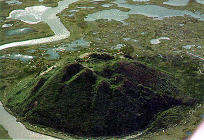
A pingo is an ice-cored hill typically conical in shape, growing and persisting only in PERMAFROST. The word "pingo" is of Inuit origin and was first used in the English-language literature by the botanist Alf E.
Signing up enhances your TCE experience with the ability to save items to your personal reading list, and access the interactive map.
Create AccountArticle
A pingo is an ice-cored hill typically conical in shape, growing and persisting only in PERMAFROST. The word "pingo" is of Inuit origin and was first used in the English-language literature by the botanist Alf E.
"https://d3d0lqu00lnqvz.cloudfront.net/media/media/5e658751-a56e-4535-9950-f641ec565a97.jpg" // resources/views/front/categories/view.blade.phphttps://d3d0lqu00lnqvz.cloudfront.net/media/media/5e658751-a56e-4535-9950-f641ec565a97.jpg
Article
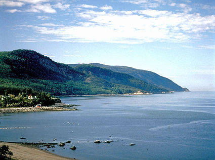
Between about 100 000 and 12 000 years ago, the whole area of Québec as well as a major part of the northern hemisphere was covered with a thick layer of ice. In the late PLEISTOCENE era, just over 12 000 years ago, Québec underwent a gradual warming of the atmosphere.
"https://d3d0lqu00lnqvz.cloudfront.net/media/media/e3cfe0fb-4ec8-418c-b14c-582f156d72a1.jpg" // resources/views/front/categories/view.blade.phphttps://d3d0lqu00lnqvz.cloudfront.net/media/media/e3cfe0fb-4ec8-418c-b14c-582f156d72a1.jpg

Article
Central US lows, entering Canada somewhere between Manitoba and Québec, are of major environmental significance because they pass through the industrial heartland of the US and frequently bring ACID RAIN.
"https://d3d0lqu00lnqvz.cloudfront.net/media/media/d32eb943-b421-42f4-bb17-0d8dbdeb99d9.jpg" // resources/views/front/categories/view.blade.phphttps://d3d0lqu00lnqvz.cloudfront.net/media/media/d32eb943-b421-42f4-bb17-0d8dbdeb99d9.jpg

Article
The amount of rain or snow that reaches the ground can vary dramatically on any particular given day, even over short distances. Many people have experienced a near-deluge of rain in their backyard, while at the same time their front yard or their neighbour's home remains quite dry.
"https://d3d0lqu00lnqvz.cloudfront.net/media/media/619882aa-a3f1-43cc-8453-b40c8eb53187.jpg" // resources/views/front/categories/view.blade.phphttps://d3d0lqu00lnqvz.cloudfront.net/media/media/619882aa-a3f1-43cc-8453-b40c8eb53187.jpg

Article
Reservoirs, as discussed here, do not include any type of subsurface reservoir structure that stores water, natural gas or oil.
"https://d3d0lqu00lnqvz.cloudfront.net/media/media/1c6f92bc-560d-45fe-a4b3-ee7504d34131.jpg" // resources/views/front/categories/view.blade.phphttps://d3d0lqu00lnqvz.cloudfront.net/media/media/1c6f92bc-560d-45fe-a4b3-ee7504d34131.jpg

Article
Réservoir Gouin, 1570 km2, elev 404 m, max length 102 km, average depth 5 m, is a collection of hundreds of small lakes containing innumerable islands in south-central Québec, equidistant from Ottawa, Montréal and Québec City.
"https://www.thecanadianencyclopedia.ca/images/tce_placeholder.jpg?v=e9dca980c9bdb3aa11e832e7ea94f5d9" // resources/views/front/categories/view.blade.phphttps://www.thecanadianencyclopedia.ca/images/tce_placeholder.jpg?v=e9dca980c9bdb3aa11e832e7ea94f5d9

Article
The Manicouagan Reservoir, 1,942 km2, elevation 360 m, is located in southeastern Quebec, about 140 km from the Labrador border. The second-largest natural lake in Quebec, it was created by a meteorite millions of years ago. The name “Manicouagan” is possibly of Innu origin and might mean “where there is bark” (for canoe making). The lake appears on Jonathan Carver’s map of Quebec (1776) as Lake Asturagamicook, and is shown to be drained by the Manicouagan or Black River.
"https://d3d0lqu00lnqvz.cloudfront.net/media/media/6be9c93a-1849-439f-b16a-f87c91691760.jpg" // resources/views/front/categories/view.blade.phphttps://d3d0lqu00lnqvz.cloudfront.net/media/media/6be9c93a-1849-439f-b16a-f87c91691760.jpg

Article
A river is a course of water, usually growing in volume between its source and its terminus in an ocean, a lake or another river.
"https://d3d0lqu00lnqvz.cloudfront.net/media/media/6206422f-7a2e-4576-abe6-c6c9e8cb75da.jpg" // resources/views/front/categories/view.blade.phphttps://d3d0lqu00lnqvz.cloudfront.net/media/media/6206422f-7a2e-4576-abe6-c6c9e8cb75da.jpg
Article
Sea ice formed by the freezing of seawater and floats on the surface of the polar oceans. Its coverage varies with the seasons; in the Northern Hemisphere sea ice ranges from a minimum of about 9 million km2 in September to a maximum of about 16 million km2 in March. In the Southern Hemisphere the range is from 3 million to 19 million km2, with the minimum and maximum coverage occurring in February and September respectively. The thickness of sea ice can vary from a few centimetres for newly formed ice in protected locations to 20 m or more in ridges; however, typical thicknesses are about 3 m in the Arctic and about 1 m in the Antarctic.
"https://d3d0lqu00lnqvz.cloudfront.net/media/media/cd41d64d-2904-401a-a652-e658f4d4926f.jpg" // resources/views/front/categories/view.blade.phphttps://d3d0lqu00lnqvz.cloudfront.net/media/media/cd41d64d-2904-401a-a652-e658f4d4926f.jpg

Article
A spring is a point of natural, concentrated groundwater discharge from soil or rock.
"https://d3d0lqu00lnqvz.cloudfront.net/media/media/24f61a09-a6c8-4eb9-9898-c8a025daa602.jpg" // resources/views/front/categories/view.blade.phphttps://d3d0lqu00lnqvz.cloudfront.net/media/media/24f61a09-a6c8-4eb9-9898-c8a025daa602.jpg

Article
Streamflow Streamflow Streamflow Originating Within and Passing Through Canada Province/ Territory Originating (cubic km) % Passing Through (cubic km) Yukon 140 4.2 165 NWT/Nunavut 700 20.8 890 British Columbia 800 23.7 870 Alberta 69 2.0 137 Saskatchewan 56 1.7 73 Manitoba 94 2.8 172 Ontario 325 9.6 500 Québec 780 23.2 1 060 New Brunswick 46 1.4 67 Nova Scotia 45 1.3 45 PEI 3.5 0.1 3.5 Newfoundland 310 9.2 310 Canada 3368 100 4292.5...
"https://www.thecanadianencyclopedia.ca/images/tce_placeholder.jpg?v=e9dca980c9bdb3aa11e832e7ea94f5d9" // resources/views/front/categories/view.blade.phphttps://www.thecanadianencyclopedia.ca/images/tce_placeholder.jpg?v=e9dca980c9bdb3aa11e832e7ea94f5d9
Article
Tidal energy is a largely untapped, renewable energy source based largely on lunar gravitation. While the potential of tidal hydroelectricity has long been recognized, compared to river dams, tidal power projects are expensive because massive structures must be built in difficult saltwater environments.
"https://d3d0lqu00lnqvz.cloudfront.net/media/media/20ec66d0-4579-4f2a-942d-5bb87ded61be.jpg" // resources/views/front/categories/view.blade.phphttps://d3d0lqu00lnqvz.cloudfront.net/media/media/20ec66d0-4579-4f2a-942d-5bb87ded61be.jpg
Article
The Earth is actually not in orbit around the sun but around the centre of mass of the Earth-sun system. Since all parts of the Earth move in the same orbit, they experience the same acceleration, but only at the Earth's centre is this acceleration exactly balanced by the sun's gravitation.
"https://d3d0lqu00lnqvz.cloudfront.net/media/media/989a9feb-532c-452f-829d-b5fecf83d434.jpg" // resources/views/front/categories/view.blade.phphttps://d3d0lqu00lnqvz.cloudfront.net/media/media/989a9feb-532c-452f-829d-b5fecf83d434.jpg

Article
Worldwide, over two-thirds of precipitation falling on land surfaces is evaporated and transpired back into the atmosphere. In Canada less than 40% is evaporated and transpired; the remainder, called the water yield, enters into streamflow.
"https://d3d0lqu00lnqvz.cloudfront.net/media/media/ba7cb000-f968-4119-b598-0a44c13c301c.jpg" // resources/views/front/categories/view.blade.phphttps://d3d0lqu00lnqvz.cloudfront.net/media/media/ba7cb000-f968-4119-b598-0a44c13c301c.jpg

Article
A waterfall is a phenomenon which occurs when water flowing in a river channel encounters a vertical or near-vertical drop in the channel bed.
"https://d3d0lqu00lnqvz.cloudfront.net/media/media/f03ee7f1-6a31-4148-8ca4-a42264dd3a8e.jpg" // resources/views/front/categories/view.blade.phphttps://d3d0lqu00lnqvz.cloudfront.net/media/media/f03ee7f1-6a31-4148-8ca4-a42264dd3a8e.jpg
